function line2kml(kmlfile,long,lat,varargin)
if nargin==0
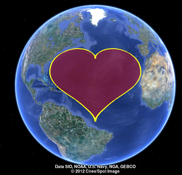
np=1000;
t=0:2*pi/np:2*pi;
r=sin(t).*sqrt(abs(cos(t)))./(sin(t)+7/5)-2*sin(t)+2;
long=r.*cos(t); lat=r.*sin(t);
long=long/max(abs(long))*31-45;
lat=lat/max(abs(lat))*35+38;
line2kml('myheart',long,lat,'style','polygon','fillcolor','r','fillalpha',127,'linecolor','y','linewidth',5,'linealpha',255);
disp(['Please open the myheart.kml file and have a look in GoogleEarth!'])
return
end
if nargin<3
help line2kml
return
end
mykml.type='Polygon';
mykml.linecolor='r';
mykml.linecolorstr='r';
mykml.linewidth=1;
mykml.fillcolor='r';
mykml.fillcolorstr='7f0000ff';
mykml.linealpha=127;
mykml.fillalpha=127;
while(size(varargin,2)>0)
switch lower(varargin{1})
case {'type','style'}
mykml.type=varargin{2};
varargin(1:2)=[];
case {'linewidth','lw'}
mykml.linewidth=varargin{2};
varargin(1:2)=[];
case {'linecolor','lc'}
mykml.linecolor=varargin{2};
varargin(1:2)=[];
case {'linealpha','linetransparency'}
mykml.linealpha=varargin{2};
varargin(1:2)=[];
case {'fillalpha','filltransparency','facealpha'}
mykml.fillalpha=varargin{2};
varargin(1:2)=[];
case {'fillcolor','fcolor'}
mykml.fillcolor=varargin{2};
varargin(1:2)=[];
otherwise
disp(['Unknown property: ',varargin{1}])
return
end
end
mykml.linecolorstr=getColor(mykml.linecolor,mykml.linealpha);
mykml.fillcolorstr=getColor(mykml.fillcolor,mykml.fillalpha);
fid=fopen([kmlfile,'.kml'],'wt');
writekmlHeader(fid,kmlfile);
long=reshape(long,1,[]); lat=reshape(lat,1,[]);
switch (mykml.type)
case {'Polygon','polygon','poly'}
fprintf(fid,'%s \n','<Style id="idpolyfill">');
fprintf(fid,'%s \n','<LineStyle>');
fprintf(fid,'%s \n',['<color>',mykml.linecolorstr,'</color>']);
fprintf(fid,'%s \n',['<width>',num2str(mykml.linewidth),'</width>']);
fprintf(fid,'%s \n','</LineStyle>');
fprintf(fid,'%s \n','<PolyStyle>');
fprintf(fid,'%s \n',['<color>',mykml.fillcolorstr,'</color>']);
fprintf(fid,'%s \n','</PolyStyle>');
fprintf(fid,'%s \n','</Style>');
fprintf(fid,'%s \n','<Placemark>');
fprintf(fid,'%s \n',['<name>',kmlfile,'</name>']);
fprintf(fid,'%s \n','<styleUrl>#idpolyfill</styleUrl>');
fprintf(fid,'%s \n','<Polygon>');
fprintf(fid,'%s \n','<tessellate>1</tessellate>');
fprintf(fid,'%s \n','<outerBoundaryIs>');
fprintf(fid,'%s \n','<LinearRing>');
case {'line'}
fprintf(fid,'%s \n','<Style id="idlineOnly">');
fprintf(fid,'%s \n','<LineStyle>');
fprintf(fid,'%s \n',['<color>',mykml.linecolorstr,'</color>']);
fprintf(fid,'%s \n',['<width>',num2str(mykml.linewidth),'</width>']);
fprintf(fid,'%s \n','</LineStyle>');
fprintf(fid,'%s \n','</Style>');
fprintf(fid,'%s \n','<Placemark>');
fprintf(fid,'%s \n',['<name>',kmlfile,'</name>']);
fprintf(fid,'%s \n','<styleUrl>#idlineOnly</styleUrl>');
fprintf(fid,'%s \n','<LineString>');
fprintf(fid,'%s \n','<tessellate>1</tessellate>');
otherwise
disp('Not defined')
end
fprintf(fid,'%s \n','<coordinates>');
%fprintf(fid,'%0.6f, %0.6f, 0.0 \n', [long;lat]);
fprintf(fid,'%0.6f,%0.6f,0 \n', [long;lat]); % update for new version google earth, 2012.10
fprintf(fid,'%s \n','</coordinates>');
switch (mykml.type)
case {'Polygon','polygon','poly'}
fprintf(fid,'%s \n','</LinearRing>');
fprintf(fid,'%s \n','</outerBoundaryIs>');
fprintf(fid,'%s \n','</Polygon>');
case {'line'}
fprintf(fid,'%s \n','</LineString>');
otherwise
disp('Not defined')
end
fprintf(fid,'%s \n','</Placemark>');
writekmlEnd(fid);
fclose(fid);
function writekmlHeader(fid,kmlName)
fprintf(fid,'%s \n','<?xml version="1.0" encoding="UTF-8"?>');
fprintf(fid,'%s','<kml xmlns="http://www.opengis.net/kml/2.2" xmlns:gx="http://www.google.com/kml/ext/2.2" ');
fprintf(fid,'%s \n','xmlns:kml="http://www.opengis.net/kml/2.2" xmlns:atom="http://www.w3.org/2005/Atom">');
fprintf(fid,'%s \n','<Document>');
fprintf(fid,'%s \n',['<name>',kmlName,'.kml</name>']);
function writekmlEnd(fid)
fprintf(fid,'%s \n','</Document>');
fprintf(fid,'%s \n','</kml>');
function colorHex=getColor(colorRGB,alpha)
colorHex='00000000';
if ischar(colorRGB)
switch lower(colorRGB)
case {'r','red'}
colorHex(1:6)='FF0000';
case {'g','green'}
colorHex(1:6)='00FF00';
case {'b','blue'}
colorHex(1:6)='0000FF';
case {'k','black'}
colorHex(1:6)='000000';
case {'y','yellow'}
colorHex(1:6)='FFFF00';
case {'m','p'}
colorHex(1:6)='FF00FF';
otherwise
error(['Unkow color option: ',colorRGB])
end
else
if (max(colorRGB)>1)
colorHex(1:2)=dec2hex(round(colorRGB(1)),2);
colorHex(3:4)=dec2hex(round(colorRGB(2)),2);
colorHex(5:6)=dec2hex(round(colorRGB(3)),2);
else
colorHex(1:2)=dec2hex(round(colorRGB(1)*255),2);
colorHex(3:4)=dec2hex(round(colorRGB(2)*255),2);
colorHex(5:6)=dec2hex(round(colorRGB(3)*255),2);
end
end
if alpha>1
colorHex(7:8)=dec2hex(round(alpha),2);
else
colorHex(7:8)=dec2hex(round(alpha*255),2);
end
colorHex=colorHex([7 8 5 6 3 4 1 2]); |